Orbit 3DM is Bentley Systems’ enterprise-scale solution for managing, sharing, and extracting value from massive 3D mapping and mobile mapping data. At Hertford Systems, we leverage Orbit 3DM to help organizations bridge the gap between raw reality capture and actionable engineering intelligence.
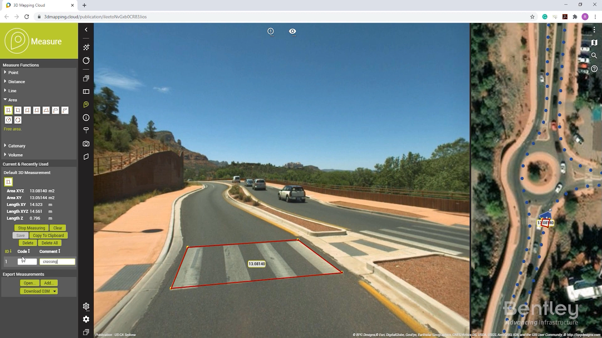
Orbit 3DM is a hardware-neutral platform designed to handle the immense datasets generated by mobile, aerial, and terrestrial mapping systems. It enables the seamless fusion of high-density point clouds, 360-degree panoramic imagery, and textured meshes into a single, high-performance environment. By providing a centralized “Content Manager” for data optimization and a “Cloud” or “Publisher” service for sharing, Orbit 3DM allows users to perform centimeter-level measurements and automated feature extraction from any web browser. The platform is a critical component of the modern digital twin, allowing infrastructure owners to manage vast “as-built” records with unprecedented speed and precision.
Orbit 3DM provides an end-to-end workflow for 3D mapping data, allowing users to visualize, analyze, and share reality data across the entire project lifecycle. Built on a scalable architecture, it supports the integration of data from any sensor—including LiDAR and oblique imagery—to create a comprehensive digital context for infrastructure assets.
The software empowers teams to automate asset inventory, perform volumetric analysis, and collaborate in real-time through secure, browser-based viewers. By connecting large-scale reality data with professional GIS and CAD environments, Orbit 3DM improves visibility for stakeholders and supports data-driven decision-making for urban planning, transportation, and utility management. Using Orbit 3DM, firms can maximize their ROI on reality capture by making complex 3D data accessible and useful to everyone in the organization.
Orbit 3DM supports a wide range of large-scale mapping and infrastructure projects across the transportation, utility, and telecommunications sectors. Key applications include:
Management and optimization of terabytes of mobile and aerial mapping data
Real-time fusion of LiDAR point clouds with 360-degree panoramic imagery
Automated feature extraction and asset inventory (signs, poles, and barriers)
Precise 3D measurements of clearances, gradients, and volumes
Cloud-based sharing of reality data for remote stakeholder collaboration
Integration of 3D mapping content into Esri, AutoCAD, and MicroStation
Long-term archival and time-lapse comparison of site condition data
Digital twin workflows for large-scale urban and corridor mapping
These capabilities allow engineers and surveyors to manage data-rich environments with higher speed and accuracy, leading to safer and more cost-optimized infrastructure operations.
Watch a introductory video for Orbit 3DM
View the product video on YouTube to learn more about its capabilities, workflows, and use cases.
SYNCHRO is Bentley’s advanced construction planning and digital twin platform that enables 4D scheduling, real-time project tracking, and improved collaboration ...
ProjectWise is Bentley’s leading project delivery and information management platform that enables teams to collaborate securely, manage engineering data, and ...